Gangtok, 7th September: A multi-department high-altitude glacial lake expedition that began on 20 August 2025 has successfully concluded, with a landmark first-ever scientific visit to Yulhe Kangse Lake (16,378 ft) in North Sikkim. The mission has returned important baseline data on the lake and other high-altitude water bodies, and will help improve understanding of mountain hydrology, geomorphology and climate links in the Eastern Himalayas.
Also Read: South Lhonak and Changsang lakes studied in latest glacial expedition in Sikkim Himalayas
The expedition included members from the Department of Mines and Geology (DMG), Sikkim Police, Sikkim State Disaster Management Authority (SSDMA), District Disaster Management Authority (DDMA), Department of Science & Technology (DST), Sikkim University (SU), Central Water Commission (CWC), Geological Survey of India (GSI), National Institute of Hydrology (NIH), National Institute of Disaster Management (NIDM), Central Water and Power Research Station (CWPRS), Himachal Pradesh State Disaster Management Authority (HPSDMA), Defence Geoinformatics Research Establishment (DGRE) and the Information and Public Relations Department (IPR). The team worked with support from the Indo-Tibetan Border Police (ITBP), the Indian Army, the local Zumsa community and Khangri Tours & Trek.
The team was divided into two groups. Team A completed its objectives at Dolma Sampa and the Sora Funnel area and returned on 26 August. Team B moved towards South Lhonak Lake. From South Lhonak, sub-team B1 (CWC, GSI, NIH, HPSDMA and DGRE) returned to Gangtok on 29 August after completing their studies. Sub-team B2 (DST, SU and IPR) advanced to Changsang Lake and later reached Thangu on 1 September. On 2 September, Team B2 prepared to move towards Yulhe Kangse Lake.
Also Read: Sikkim Among States with Rapidly Expanding Glacial Lakes, CWC Warns
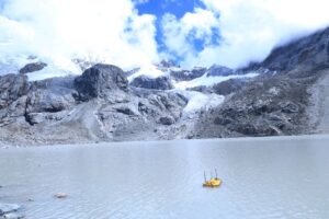
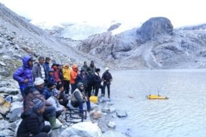
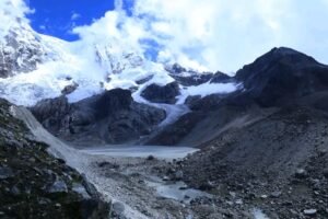
On 3 September (Day 15) the team reached Yulhe Kangse Base Camp and spent the night there. On 4 September (Day 16) the scientists trekked to Yulhe Kangse Lake where a traditional puja was performed before beginning the first-ever bathymetric survey and sediment sampling at the site. These field studies captured the lake’s depth profile, sediment composition and other baseline measurements crucial for assessing the lake’s behaviour, stability and linkages with regional hydrology and climate change.
After completing work at Yulhe Kangse, the team left base camp on 5 September (Day 17), halted at Lachung overnight, and reached Gangtok on 6 September (Day 18), marking the end of this phase of the expedition. The mission returned with several important observations and data sets that are expected to provide fresh insights into the geomorphology, hydrology and climate interactions of high-altitude lake systems.
The Science and Technology Department thanked all participating agencies and partners for their coordinated effort and support. The department said the data from Yulhe Kangse and the other lakes studied during the expedition will inform future monitoring, early-warning planning and climate resilience measures for vulnerable downstream communities.